Distrito de Erlangen-Höchstadt
| Distrito de Erlangen-Höchstadt Landkreis Erlangen-Höchstadt | ||||
|---|---|---|---|---|
| Distrito | ||||
| ||||
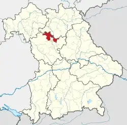 Ubicación del distrito de Erlangen-Höchstadt en Baviera | ||||
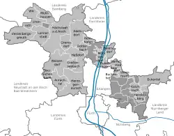 Mapa del distrito (municipios y ciudades) | ||||
| Coordenadas | 49°40′N 10°50′E / 49.67, 10.83 | |||
| Capital | Erlangen | |||
| Entidad | Distrito | |||
| • País | Alemania | |||
| • Estado | Baviera | |||
| • Región | Franconia Media | |||
| Superficie | ||||
| • Total | 564,66 km² | |||
| Altitud | ||||
| • Media | 287 m s. n. m. | |||
| Población (2017) | ||||
| • Total | 135 334 hab. | |||
| • Densidad | 2,4 hab./km² | |||
| Huso horario | UTC+01:00 y UTC+02:00 | |||
| Matrícula | ERH y HÖS | |||
| Sitio web oficial | ||||


Erlangen-Höchstadt es uno de los 71 distritos en que está dividido administrativamente el estado alemán de Baviera.
Ciudades y municipios
| Ciudades | Municipios | |
|---|---|---|
Véase también
 Datos: Q10447
 Multimedia: Landkreis Erlangen-Höchstadt / Q10447