Sankt Ingbert
| Sankt Ingbert | ||||
|---|---|---|---|---|
| Municipio | ||||
 | ||||
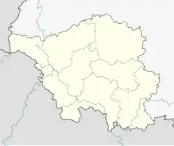 Sankt Ingbert Ubicación en el estado de Sarre | ||||
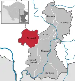 Ubicación en el distrito | ||||
| Coordenadas | 49°16′44″N 7°06′54″E / 49.278888888889, 7.115 | |||
| Entidad | Municipio | |||
| • País | Alemania | |||
| • Estado | Sarre | |||
| • Distrito | Sarre-Palatinado | |||
| Superficie | ||||
| • Total | 49,95 km² | |||
| Altitud | ||||
| • Media | 234 m s. n. m. | |||
| Población (2023) | ||||
| • Total | 35 059 hab. | |||
| • Densidad | 701,88 hab./km² | |||
| Huso horario | UTC+01:00 y UTC+02:00 | |||
| Código postal | 66386[1] | |||
| Prefijo telefónico | 06894 | |||
| Matrícula | IGB | |||
| Número oficial de comunidad | 10045117 | |||
| Sitio web oficial | ||||
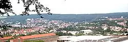
Con sus 38.700 habitantes, Sankt Ingbert es la quinta ciudad más grande del Sarre y está situado a aprox. 10 km de Saarbrücken.
Consta de los distritos de St. Ingbert-Mitte (St. Ingbert Central; en el cual se incluye Sengscheid), Rohrbach, Hassel, Oberwürzbach (con Reichenbrunn y Rittersmühle) y Rentrisch.
Hasta los años 70 era una importante ciudad de minería.
 Datos: Q14907
 Multimedia: St. Ingbert / Q14907
- ↑ Worldpostalcodes.org, código postal n.º 66386.