Mons Ampère
Mons Ampère (Monte Ampère en latín) es una montaña lunar ubicada aproximadamente en las coordenadas 19°N 4°O, en el centro de los Montes Apeninos.[1] La longitud del tramo montañoso es de unos 30 km.
| Mons Ampère | ||
|---|---|---|
 Mons Ampère. Foto: LRO. | ||
| Coordenadas | 19°19′N 3°43′O | |
| Localización administrativa | ||
| Localización | La Luna | |
| Características generales | ||
| Tipo | Montaña lunar | |
| Altitud | 1300 m (sobre el Mare Imbrium) | |
|
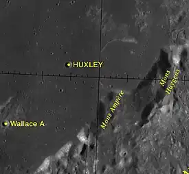
Localización sobre el mapa lunar  <div style="position: relative; left:Expresión errónea: operador * inesperadopx; top:Expresión errónea: operador * inesperadopx">
 | ||
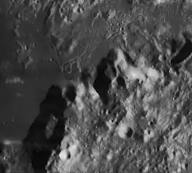
Mons Ampère, con el mons Huygens a la derecha (Imagen Lunar Orbiter 4
El cráter más próximo es Huxley, situado unos 40 km al nor-noroeste. La elevación aproximada del monte sobre el nivel del Mare Imbrium es de unos 1300 m.[2]
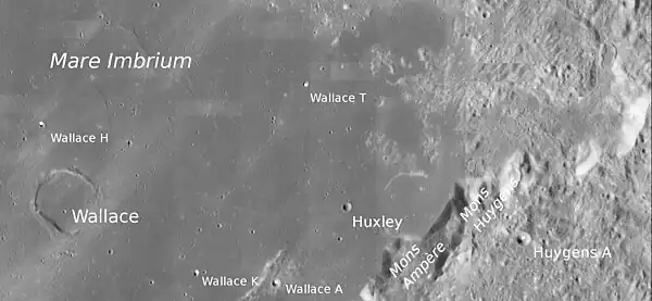 El mont Ampère abajo de la imagen |
Referencias
- (WGPSN), IAU Working Group for Planetary System Nomenclature (13 de febrero de 2013). «Gazetteer of Planetary Nomenclature. 1:1 Million-Scale Maps of the Moon» (en inglés). UAI / USGS. Consultado el 6 de abril de 2016.
- Andersson, L. E.; Whitaker, E. A., (1982). NASA Catalogue of Lunar Nomenclature (en inglés). NASA RP-1097.
- Blue, Jennifer (25 de julio de 2007). «Gazetteer of Planetary Nomenclature» (en inglés). USGS. Consultado el 2 de enero de 2012.
- Bussey, B.; Spudis, P. (2004). The Clementine Atlas of the Moon (en inglés). Nueva York: Cambridge University Press. ISBN 0-521-81528-2.
- Cocks, Elijah E.; Cocks, Josiah C. (1995). Who's Who on the Moon: A Biographical Dictionary of Lunar Nomenclature (en inglés). Tudor Publishers. ISBN 0-936389-27-3.
- McDowell, Jonathan (15 de julio de 200). «Lunar Nomenclature» (en inglés). Jonathan's Space Report. Consultado el 2 de enero de 2012.
- Menzel, D. H.; Minnaert, M.; Levin, B.; Dollfus, A.; Bell, B. (1971). «Report on Lunar Nomenclature by The Working Group of Commission 17 of the IAU». Space Science Reviews (en inglés) 12: 136.
- Moore, Patrick (2001). On the Moon (en inglés). Sterling Publishing Co. ISBN 0-304-35469-4.
- Price, Fred W. (1988). The Moon Observer's Handbook (en inglés). Cambridge University Press. ISBN 0521335000.
- Rükl, Antonín (1990). Atlas of the Moon (en inglés). Kalmbach Books. ISBN 0-913135-17-8.
- Webb, Rev. T. W. (1962). Celestial Objects for Common Telescopes, 6ª edición revisada (en inglés). Dover. ISBN 0-486-20917-2.
- Whitaker, Ewen A. (2003). Mapping and Naming the Moon (en inglés). Cambridge University Press. 978-0-521-54414-6.
- Wlasuk, Peter T. (2000). Observing the Moon (en inglés). Springer. ISBN 1-85233-193-3.
- «Lunar Impact Crater Database» (en inglés). Lunar and Planetary Institute (USRA). Consultado el 12 de septiembre de 2017.
Véase también
Enlaces externos
 Wikimedia Commons alberga una categoría multimedia sobre Mons Ampère.
- LPI. Digital Lunar Orbiter Photographic Atlas of the Moon.
- Mapa LROC
- Referencia USGS Mons Ampère
| Control de autoridades |
|
|---|
 Datos: Q627051
- Multimedia: Mons Ampère / Q627051
Este artículo ha sido escrito por Wikipedia. El texto está disponible bajo la licencia Creative Commons - Atribución - CompartirIgual. Pueden aplicarse cláusulas adicionales a los archivos multimedia.